
January 27th, 2009
My first piece of solid specific history on Gargoyle Gulch comes from an aerial photo taken on July 26th, 1966:
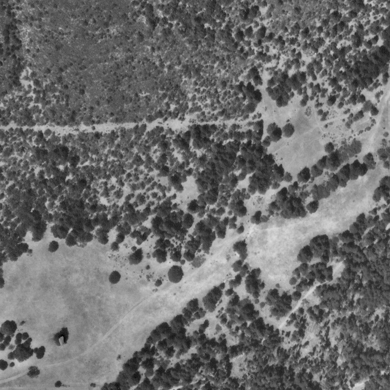
This may not seem like much but in fact there’s a lot of information in this image. Start with the horizontal line stretching across the image about one-third of the way down from the top. That’s a cleared area, but it’s only about ten feet wide. It’s the clearance work that had to be done to set up the new power line that was installed at about that time. The power goes from west to east across the property and continues on eastward for another half mile or so to another place that was built around then.
You can also see a dirt road curving upwards from the lower left corner of the photo. That’s the main road onto the property and it follows the contour of the land; the current road follows exactly the same path. It continues almost to the center of the property, where it comes to the creek; there it dies down to a mere track and continues eastward.
Nobody lived on the land at this time. This road was probably used by the local cattlemen to check up on their cattle. You can see the trails made by the cattle; they show up as weak lines that aren’t particularly straight. Otherwise, the land was pretty much empty and unused. Nevertheless, it had already undergone logging. There are stumps on the land that are certainly older than 40 years. And a dead giveaway is the shape of the land in the southeast (lower right) corner of the land. It’s a slope facing northwest. Notice how open it is, and how few tall trees there are. (Tall trees are dark.) The entire area in the lower right corner that has trees is part of the hill slope. That’s a cool slope because it faces northwest. It should therefore be covered with a dense forest of Douglas Fir. Instead, it’s open, with just small trees. I estimate from this that the hillside was clearcut less than ten years before this picture was taken.
Remember the road I mentioned that was claimed to be part of the original road from Jacksonville to Sterling Creek? You can see it running along the lower section of the southeast hill; it slopes diagonally up and towards the right from the bottom of the image. It’s on a steep slope. My guess is that this was the logging road they used to clearcut the slope. The trees were cut down and then dragged down the slope to the logging trucks waiting on the road.
Notice the smooth gray area in the upper left section of the image. That’s solid manzanita. There are a lot of small scrub oaks scattered through the area, but mostly it’s just a solid mass of manzanita.
As we progress through the aerial photos you’ll be able to see the history of Gargoyle Gulch for yourself.